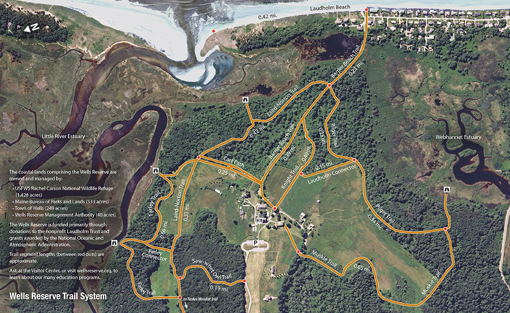
Trail Map
Explore the Maine coast on your own or join one of our naturalists for a tour.
Our easy to moderate trails are open year round for hiking, snowshoeing, and cross-country skiing. (Trails are not groomed in winter.)
All trails are currently open. Recent storms have affected many of our trails, so please use caution when you visit. We appreciate your patience as we work to improve the condition of the trails.
Trails are open every day — 7am to sunset.
Read a complete copy of Rules for Public Use of Wells Reserve.
Please be prepared for biting insects, ticks, poison ivy, and other wonders of nature. Carry water and a snack.
Looking for hands-on activities for your family? Stop in at the Visitor Center and check out a Discovery Backpack.
Our trails feature signs to help you find your way, identify plants and animals, understand the natural and cultural history of the site, and explore landscape change.
The best route to the beach starts with a broad view over grasslands with Mount Agamenticus in the distance. Continue through an abandoned apple orchard and an aspen grove, then over a dike and out the Drakes Island gate toward Laudholm Beach.
High tide leaves little beach for walking, but otherwise plan for cobbles, sand, and ancient peat for walking and tide pools for exploring. The Little River mouth is a half-mile to the northeast, where barrier dunes protect a small mud flat. In the summer, please give piping plovers and least terns plenty of room.
Start on the Barrier Beach Trail, but take an early left to follow the Cart Path downhill. The short trail divides old farm buildings and open grasslands from brush and woods. A gate blocks “research road” (not open to the public), with the Laird-Norton boardwalk going off to the right. This trail cuts through both dry and wet areas with mixed woodland and a thick understory.
Watch for the Barrier Beach Overlook, a short spur to a deck on the edge of the salt marsh and a beautiful view of the Little River mouth. Across the expanse is a barrier dune, which backs Laudholm Beach.
Continue on the boardwalk to find the crossing of the Barrier Beach Trail. Turn left to visit the beach. Turn right to return to the Laudholm campus.
From the parking lot, backtrack along the entry road to the beginning of the Saw-whet Trail. Mature conifers and hardwoods loom over the first section of trail, which also features the Forest Learning Shelter, a rustic teaching environment for education programs focused on forest ecology.
The Saw-whet Trail ends in a T. To the left is the head of the Farley Trail or, further along and across Skinner Mill Road, the Yankee Woodlot Trail. The Farley crosses a field before entering more deep woods. At the Little River, a small overlook offers views across the estuary. As the trail continues, it passes through more woods then out to open fields before winding through a brushy tangle and arriving at another overlook. A dock here is used for kayak and field trip programs.
Exiting the overlook soon leads to the bottom of the Cart Path, which connects back to the Laudholm Campus.
Two Picture Posts are accessible on our trails, one on the Knight Trail and another in the Yankee Woodlot. See how they work.