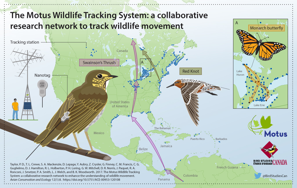
Motus Wildlife Tracking System
Since 2013, the Wells Reserve has hosted a receiving station as part of the Motus Wildlife Tracking System, an international network of researchers using coordinated, automated radio-telemetry arrays to study movements of small flying organisms including birds, bats, and insects.
The nanotag transmitters attached to studied animals weigh as little as 0.3 gram and emit a coded microburst pulse that allows each tag to be instantly and individually identified.
Background
The Motus Network traces its roots to 2012, when it began as sensorgnome.org through Acadia University in Nova Scotia. It later became a program of Bird Studies Canada in partnership with Acadia University and other collaborating researchers and organizations. The network was formally introduced to the scientific community in 2017.
The U.S. Fish & Wildlife Service has provided intellectual and financial support to the Motus Network. The Wells Reserve station is maintained by biologists from the Rachel Carson National Wildlife Refuge.
Receiving Station
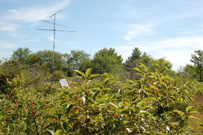
The Wells Reserve receiving station includes three mast-mounted, directional antennas (9-element Yagi-Uda) connected to a software-defined radio (FunCube Dongle). A solar panel powers the radio. The station has remained in one location since it was installed, but it receives a new station ID whenever a change is made to its configuration, such as replacing the radio or reorienting the antennas. View current and past station descriptions.
The Wells station was originally installed to help track two migratory bird species that fly over the Gulf of Maine. Since its activation, the station has been capturing data whenever tagged animals move close enough for detection (up to about 20 km). The data are aggregated at motus.org.
Results
Between June 9, 2014 and October 17, 2022, the Wells Reserve station detected 286 tags carried by 32 bird species and 1 bat.
Noteworthy Detections
- A Semipalmated Sandpiper tagged on Coats Island at the north end of Hudson Bay on July 12, 2014, was detected by the Wells station on July 30, 2014.
- A Blackpoll Warbler tagged on April 14, 2022 in Colombia was detected by the Wells station on May 25, 2022.
Publications
A partial list of publications resulting from studies that have incorporated data captured by the Wells Reserve receiving station.
Smetzer JR, King DI, Taylor PD. 2017. Fall migratory departure decisions and routes of blackpoll warblers Setophaga striata and red-eyed vireos Vireo olivaceus at a coastal barrier in the Gulf of Maine. Journal of Avian Biology 48:1451-1461.
Duijns S and others. 2019. Long-distance migratory shorebirds travel faster towards their breeding grounds, but fly faster post-breeding. Scientific Reports 9.
Holberton R and others. 2019. Automated VHF radiotelemetry revealed site-specific differences in fall migration strategies of semipalmated sandpipers on stopover in the Gulf of Maine. Frontiers in Ecology and Evolution 7.
Education
The Northeast Motus Collaboration graciously shared a signage template that is to be adapted for use along the Knight Trail.
Partners
Rachel Carson National Wildlife Refuge