The Wrack
The Wrack is the Wells Reserve blog, our collective logbook on the web.
The Wrack is the Wells Reserve blog, our collective logbook on the web.
The Piscataqua Region Estuaries Partnership convened the Salmon Falls Watershed Collaborative to improve watershed planning and management — and to protect water supply sources — in the Salmon Falls River watershed.
The Land Conservation Plan for Maine’s Piscataqua Region Watersheds aims to identify and describe areas that represent the best opportunities to conserve the critical ecological, biological, and water resources of southern Maine's coastal watersheds. These Conservation Focus Areas (CFA) are presented in the plan as a series of double-sided pages that include a map of each specific area plus detailed information about its significant resources. Each CFA fact sheet is available individually here:
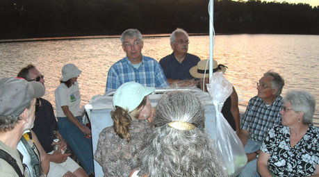 29 people representing 13 towns and organization participated in three boat trips on the Salmon Falls and Piscataqua Rivers in July and August. The trips coincided with the release of the new Land Conservation Plan for Maine's Piscataqua Region Watersheds that covers 18 communities in southern Maine. The narrated tours brought together key municipal officials and conservation leaders to learn about the plan, its goals, and the river's status and history.
Land use changes, particularly the loss of vegetation along the water edges (associated with residential development), are having a significant impact on water quality. The Land Conservation Plan outlines actions that towns and citizens can take to maintain the natural, recreational, and economic resources that this watershed, draining 1058 square miles, provides.
The Piscataqua Region Estuaries Partnership has released its Land Conservation Plan for Maine's Piscataqua Region Watersheds (14MB PDF).
The plan provides a scientific and experienced-based guide for the protection of natural resources vital to thriving communities. It is designed to assist citizens who are involved in sustaining and improving their communities by serving on select boards, planning boards, conservation commissions, economic development boards, schools, or non-profit community organizations such as land trusts, watershed coalitions, conservation groups, and recreation clubs.