The Wrack
The Wrack is the Wells Reserve blog, our collective logbook on the web.
The Wrack is the Wells Reserve blog, our collective logbook on the web.
 Three angles of investigation into three waterways flowing through three municipalities have reached one encouraging conclusion: The Merriland River, Branch Brook, and the Little River are ecologically healthy and the people largely responsible, those living in the combined watershed, know and appreciate it.
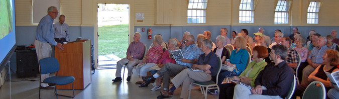
The design for our Sustaining Coastal Landscapes and Community Benefits project, the first study of its kind, drew from the sciences of ecology, economy, and communications. Reserve staff and their colleagues from Clark University looked at streamside buffers in Sanford, Kennebunk, and Wells to find out how they affect life in the water and how members of the community value them.
For the second time in less than a year, the Town of Wells and the Wells National Estuarine Research Reserve have teamed up to protect a key parcel of land in the Merriland River watershed.
 The 61-acre Highpine Properties parcel consists of forested wetlands, vernal pools, and the headwater streams of the Merriland River. The undeveloped tract has 100 feet of frontage on the Sanford Road (Route 109) and is nestled into the 700-acre Fenderson Wildlife Commons, a designated town conservation area. Protecting the Highpine parcel adds to one of the largest blocks of unfragmented conservation land in southern Maine.
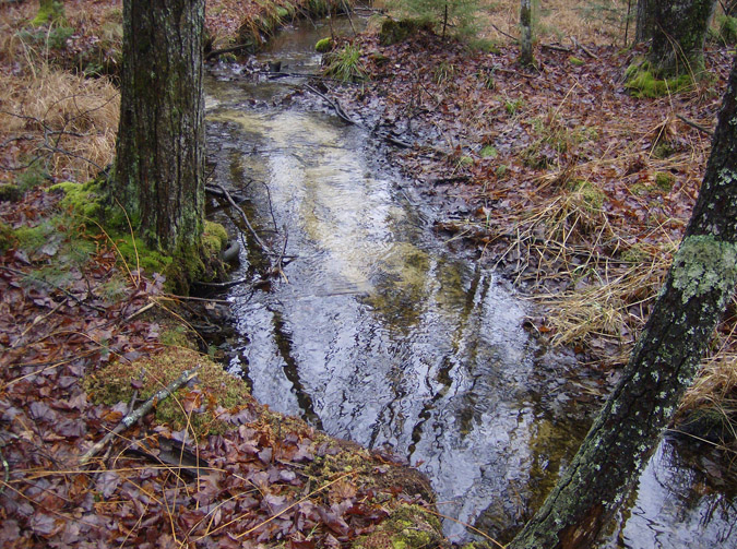
It’s that time of year… fall is in the air and (if you’re a brook trout) love is in the air too! October and November is prime spawning time for Eastern Brook Trout. They’ve been fattening up all summer on aquatic insects. Now the mature females have bellies full of eggs and are looking for a spots with cold, clear water and loose, clean gravel where they can make their nests, called redds.
Back in July, Wells Reserve staff and interns teamed up with volunteers from the Sebago Chapter of Trout Unlimited and bravely struck out on an ambitious survey of road-stream crossings in the Kennebunk River, Merriland River, and Branch Brook. The teams worked hard and surveyed an amazing 81 road-stream crossings in only three days!
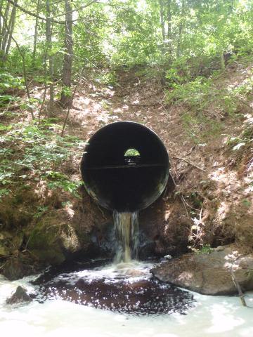 I led one of the survey teams and let me tell you, that data was hard-earned! Once we had located a crossing, we had to battle thick brush, mud, poison ivy and steep slopes of riprap to reach the stream. To measure the length of a crossing, we sometimes had to crawl through a culvert from one end to the other, dodging spider webs along the way. Besides being a fun excuse to go crashing through woods and splashing through rivers, this survey was an important way to gather data that will be used by town planners, landowners, conservation groups, and other stakeholders to reconnect stream habitat in these watersheds.
I want to share some pictures that highlight some nice days for research throughout the local area, including the Saco River, the Merriland River, Branch Brook, the Little River Salt Marsh, and Big Daddy's Ice Cream.
Have you ever wondered what watershed conservation is all about? Do you often consider where the water in your local river travels, and how its care affects your community and others down the river? Here at the Wells Reserve we work with watershed conservation on a day-to-day basis. Watersheds are areas of land which share a common feature—all water that flows above or underground drains to the same place. The Saco River watershed connects diverse areas such as North Conway, NH, and Biddeford, ME. The lives of the people who live within these areas are affected by the health—conservation—of their watershed.
WELLS, Maine, January 26, 2012 — A 105-acre property that connects 540 acres of existing conservation land has been permanently protected by the Town of Wells in partnership with the Wells National Estuarine Research Reserve at Laudholm.
The Tilton parcel, as it is known, contains 5,250 feet of frontage along the Merriland River, ecologically significant wetlands, and forested uplands. It protects habitat for a variety of wildlife, scenic views, and historic stone walls, and will provide for recreational and educational opportunities for the public.
WELLS, Maine, September 2, 2011 — The Wells National Estuarine Research Reserve has received a $287,000 federal grant to assist with the permanent protection of a 130-acre parcel with high conservation value along the Merriland River in Wells. The Wells Reserve and the Wells Conservation Commission collaborated in requesting the grant, which was awarded by the National Oceanic and Atmospheric Administration’s Coastal and Estuarine Land Conservation Program.